View Interactive Map
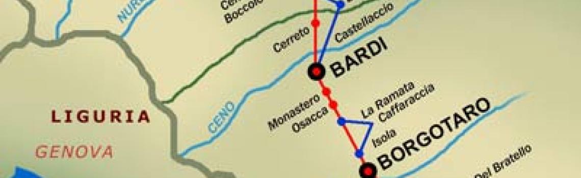

THE ABBOTS WAY
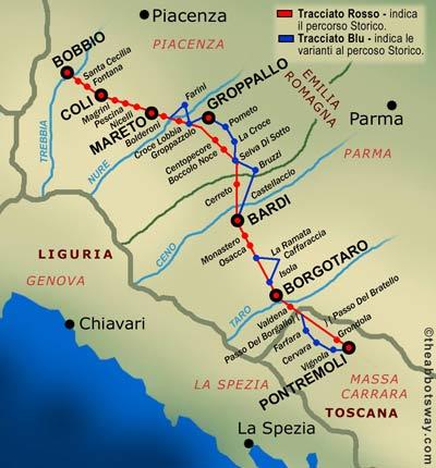


From Pavia to Bobbio
The route, starting at Pavia and heading first towards the Po valley hills and then the Apennine ridge of Mount Penice, consists of three parts of almost equal length (about 20 kilometres each): one before the plain (from Pavia to Broni and the foothills); the second one over hills (ending at Pometo/Caminata); the third one over high hills and ending on a mountain (from Caminata to the ridge of Mount Penice), then descending towards Bobbio.
You exit at the East outskirts of Pavia, passing by the small Romanesque church of San Lazzaro, a pilgrims' stop, and following the Via Francigena. As the houses end, you leave the Via Francigena and head south, following the Green Way of the Ticino Park. This path has been recently cleared of natural vegetation and the Ticino Park Authority has had path signs installed (CAI-type white-red ones, initials GW).
You follow the path running parallel to the river until you reach Ponte della Becca bridge, at the confluence of the Po and Ticino rivers (6 km). Only cars travelling at the limited speed of 40/50 km/h are allowed to cross the bridge as are, obviously, pedestrians and cyclists.
Once you have crossed the bridge, you turn left onto the main embankment of the Po river (unpaved and without traffic) and follow it until you turn towards the hills, in the direction of Broni-Stradella.
At Broni (16 km from Pavia: via dei Mille, via Cairoli, via Volta, via Emilia, via Dante, and finally Monte Grappa) you go up the old Via Dell'Acqua Calda (unpaved and without traffic) until Colombarone (18 km), located at the start of the ridge of the hills separating the Scuropasso Valley from the Versa Valley.
From Colombarone you then follow the whole length of the ridge (on the Acqua Calda provincial road, paved but with little, local traffic) passing through the localities of Castana, Sannazzaro, Cella, Spagna and Francia (the latter not included in the photocopy of sheet B) and then Ca' Tessitori (at the top of sheet C), where you turn onto the dirt road and follow it to Canevino and finally to Pometo (38 km from Pavia).
From Pometo you walk 4 kilometres down the Tidone Valley to Caminata, an old fortified village (today in the province of Piacenza), you cross the bridge over the river and start walking uphill again towards Ronchi, Trebecco, Fontanasso, Casa Bobbiese, Ca' dei Giorgi, Cappelletta (26-69), where you walk over the hills in a south-east direction and then at an altitude of 752m (69/27E) you go south (leaving Ca' di Lazzarello behind you). From there, following the CAI 219-19 path, you reach Praticchia-Grazzi (about 56 km from Pavia).
From Paticchia-Grazzi (12 km from Bobbio) take the CAI 201-19 path southwards until you meet the 201 path, follow it to the 1001 path and following the CAI arrow (for which we don't have the numbers as they were marked only recently) still going south you reach Sassi Neri.
You leave the paved Penice road and (turning left and then right) you will meet the paved municipal road for Gorazze, which you take downhill. After a few hundred metres (at Croce), a dirt road on the left descends past the Oratory of the Madonna of Caravaggio and. leaving Castighino on the left, becomes paved. You follow the road until you reach La Valle.
Just beyond La Valle, going south, you take the dirt road on the left (called La Squera, old Salt Road towards Milan) and in 20 minutes you reach Bobbio.
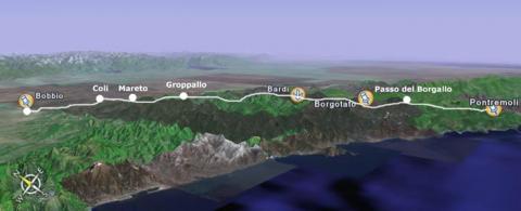
The Bobbio-Pontremoli itinerary
This route, regularly taken by abbots travelling to Rome, was once also busy with people and means of transport travelling back and forth between Bobbio and the Monastery's estates in the Taro and Ceno Valleys and in Tuscany. There were also Irish and other pilgrims, both clerical and lay ones, who on their journey to Rome would stop at the abbey to visit the tomb of Saint Colombano. Starting in 862, the monks ran a hospice in Piacenza, at the Santa Brigida church, mostly for the Irish pilgrims on their way to the monastery of Bobbio and Rome. The route would also have seen, at certain times, the passage of armies, bandits and smugglers.
The route can be divided into two sections:
Bobbio - Boccolo dei Tassi - Bardi section, in which a number of roads make it possible to cross the Coli and Nure Valley territory and reach Boccole dei Tassi, a regular stop for the Bobbio abbots, who could rest here before going on to Bardi.
Bardi - Borgo Val di Taro - Pontremoli section, which partly overlaps the so-called "Way of the Monasteries", which connected the monasteries in the plain with those in the Tolla Valley, Gravago and Pontremoli, and then continued on to Rome.
The marked road shows points where there were dependencies of the monks of Saint Colombano registered in the diplomatic Code of the Monastery of Bobbio. These make it easier to identify the route, which can still be followed today with few variations. The marked points are: Bobbio, Boccolo dei Tassi, Monastery of Gravago, Borgo Val di Taro, Borgallo Pass, Pontremoli.
From Bobbio to Boccolo dei Tassi
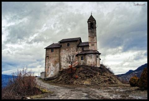
Starting from the Abbey of Bobbio, you cross the Ponte Gobbo bridge, and then climb towards Case Gambado, Bellocchi, Santa Cecilia and reach Coli, near the Saint Colombano cave. Then, beyond the ruins of the Magrini castle and after crossing the Curiasca stream, you reach the former fortified building of Faraneto; from here, at a distance of about 500 metres, you can see Peli where, on the site of the church, there used to be a fortification. You reach Pescina, a locality where the ruins of high-medieval structures have been found and you climb towards la Sella dei Generali, where oral tradition remembers the ruins of a watchtower, which was probably built here to monitor the route.
You reach the Fontanone (the fountain) and descend towards Nicelli. The castle, now gone, is said to have been given as "a very distinguished gift" by the Emperor Charlemagne to the Nicellis, the powerful lords of the high Nure Valley, who had served him well in the war against Desiderius. It is called "court of the Nicellis" in Emperor Otto's investiture of the abbot of Bobbio. The first deed relating to it dates back to 1207. The current ruins of the house-tower retain a few traces of high medieval architecture.
From Nicelli you can see Mareto (off route), not far from Cogno San Savino, mentioned in a document of 999. Today only the area on which the castle was built remains, but we can still admire the very beautiful Romanesque tower of the church.
After Molino de' Mortè, Vigonzano and Guglieri, you reach Crocelobbia: here, past the church, if the weather conditions allow it (this is more likely in the summer period), you can ford the Nure stream. Otherwise you can take the route for Farini (where you can get refreshments) and Canova. You finally take the mule track for Groppazzolo, which can also be reached taking the "main" road. From this locality, once the fortified place of the family of the same name, proud enemy of the Nicellis, you climb to Groppallo.
From this village you go towards Croce. Nearby, in Tornara (off route), is the tower of the same name, watching over the route that connected the Piacenza and Parma territories. Originally four stories high, it is now reduced to three. Mentioned in a deed of 1576, the building was inhabited by Sir Bernardo Cavanna, owner of lands and 925 heads of cattle.
Descending from Croce towards Selva Sotto, between two brooks, you come across the medieval tower of Saint Antonino, now in poor condition. After crossing the provincial road, you climb towards Selva Sopra and go on to Bruzzi and the Linguadà pass, descend towards Le Chiastre and, after a curve in the road, you bear left for Boccolo dei Tassi.
About 500 metres before the Linguadà pass, weather permitting, you can choose to turn left to take the scenic and challenging Mount Lama alternative route. This way you can avoid the Provincial Road 77 and reach Bardi following the white-red signs. Mount Lama, the largest outcrop of jasper in Emilia Romagna, where many finds from the Palaeolithic era have been made, reaches a height of 1347 metres above sea level. From the top, among serpentine beech trees twisted by the wind, serpentines and jaspers, you can enjoy a superb view of the Alps and Apennines. Along the ridges, a safe hiding place for many partisans in the last war, people gather mushrooms and berries, watched by grazing Bardigiano horses.
From Boccolo dei Tassi to to Bardi
At Boccolo dei Tassi, in the valley, there used to be a church with a hospice that welcomed pilgrims, travellers, the sick and the poor. The church, whose chaplain was appointed by the abbot of Bobbio, was dedicated to St. Peter, whom the Longobards, too, venerated as the gatekeeper of heaven. It was located in the middle of rich farming estates, as can be deduced by the amount of the rent, about one quarter of their revenues, that were paid to the abbey: 93 bushes of grain, as well as hay, workdays, etc. The ruins of the hospice, recently discovered, are located on the left bank of the Dorbora stream, near the ancient Linguadà - Bardi route. Of the original church, rebuilt several times and finally abandoned, only a statue of St. Peter remains, now kept in the current church.
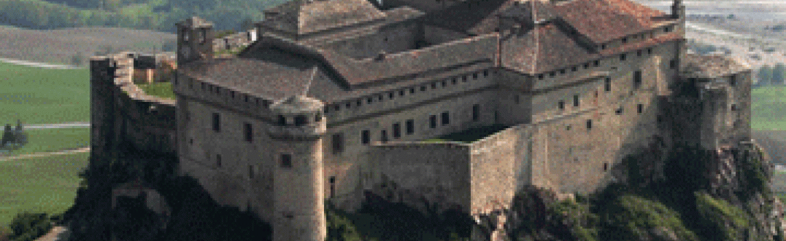
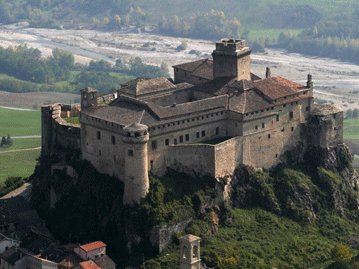
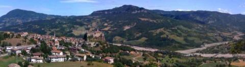
From this locality you continue towards Cerreto, take the provincial road for about 1 kilometre and then the path on the left for Cogno di Grezzo. Here you go back on the Provincial Road SP 77, cross the village of Grezzo and after about 3 kilometres reach the Romanesque church of St. Syrus, where you can enjoy a beautiful view of the Ceno Valley and the Fortress of Bardi. The fortress, mentioned in documents as early as 898, was built in a strategic position - probably against the advance of the Magyars - and still overlooks the torrent and its tributaries Noveglia and Toncina.
The current structure is the result of several additions, particularly those built between the 15th and 16th centuries by Manfredo, Agostino and Claudio Landi and, between the 16th and 17th centuries, by Prince Federico, who transformed the medieval fortress into a sumptuous mansion. With the extinction of the dynasty (1679) - the last Landi woman married a Doria of Genoa - the castle was sold to the Farnese and, after becoming a military garrison, it followed the fortunes of the Duchy of Parma and Piacenza until the unification of Italy, when it became the property of the municipality.
Currently the fortress is the site of the Museums of Peasant Civilization and of Poaching, and it is part of the "Castles of the Duchy of Parma and Piacenza" circuit. There are interesting rooms with frescoes representing the domains of the Landi and Grimaldi of Monaco families: Maria Landi, in 1595, married Ercole Grimaldi; their son, Onorato, inherited the title from his mother, and was the first Prince of Monaco. At the foot of the castle is the deconsecrated church of St. Francis, which Juana of Cordoba and Aragon, wife of Claudio Landi, had built in 1571-1579 as a family Pantheon. Under Federico, the church, rebuilt in its current form, passed to the Franciscan friars of Genoa; a convent was annexed to it, and later suppressed under Napoleon. The current auditorium, owned by the municipality and managed by the Research Centre of the Ceno Valley, hosts exhibitions, lectures and concerts.
A stop in Bardi makes it possible to visit the churches of San Giovanni (1500-1700) and of the Addolorata (about 1930) with an important altarpiece by Parmigianino, the historical centre with its alleys, and the former Maria Luigia palace, which was probably the site of the municipality offices under the Landis. The Duchess had a theatre built in it, which has now been turned into a conference hall.
At km. 1, there is the 17th-century Oratory of Santa Maria delle Grazie , at km. 6, the medieval rural church of Casanova (off the chart), with internal structures dating to the 10th-12th centuries and an important "Assumption" by the Mannerist painter Malosso.
Surrounding Bardi are the mountain peaks of Ragola and Nero (with the only surviving specimens of Pinus Uncinata Miller), Pelpi, Barigozzo (on a plateau at 977 metres above sea level rise the ruins of the high medieval fortified village of Città d'Umbria), Carameto, Lama, etc, which can be reached through paths immersed in nature that deserves to be rediscovered.
From Bardi to the ridge
After descending from Bardi along the old municipal road (803) and crossing the Ceno river on the current bridge (the ford was slightly further downstream, in Tolarolo), you climb the right bank of the Noveglia stream towards Chiappa, then turn left (803b) towards Predario; both place names refer to the main activity of the area, the extraction of sandstone for building. After about 1 km you take the unpaved path on the left to reach the Monastery of Gravago. Particularly interesting are the ruins of the nearby "Caminata", a fortified refuge belonging to the founder of the Landi family, Ubertino, and the church dedicated to St. Michael. The latter, now in Baroque style, together with its adjoining monastery originates from the 8th century and is mentioned in a royal diploma of Liutprand.
After taking the path that climbs towards the Three Crosses (Tre Croci) and crossing a group of houses, you return for a short stretch on the paved road to reach Brè, interesting for its ancient urban area with house-tower.
You descend towards the Rosta stream, known for its waterfalls, and you ford it near a mill that was probably already active in the 13th century and served Caminata and the Gravago castle, whose ruins dominate the narrow valley together with the remains of the tower called "Battagliola", located even higher up.
Once you are near Gravago, leaving on your left the wood of centuries-old chestnut trees in Sant'Anna, you pass an architecturally remarkable washing trough and, going on, you come across the Pieve (rural church), inside which you can admire a beautiful 16th-century altar from the Cathedral of Massa.
You continue along the hillside until you reach the mill on the Brugnola stream; behind the ruined building are the remains of the canalization and of the old water storage pool, particularly interesting because of its size.
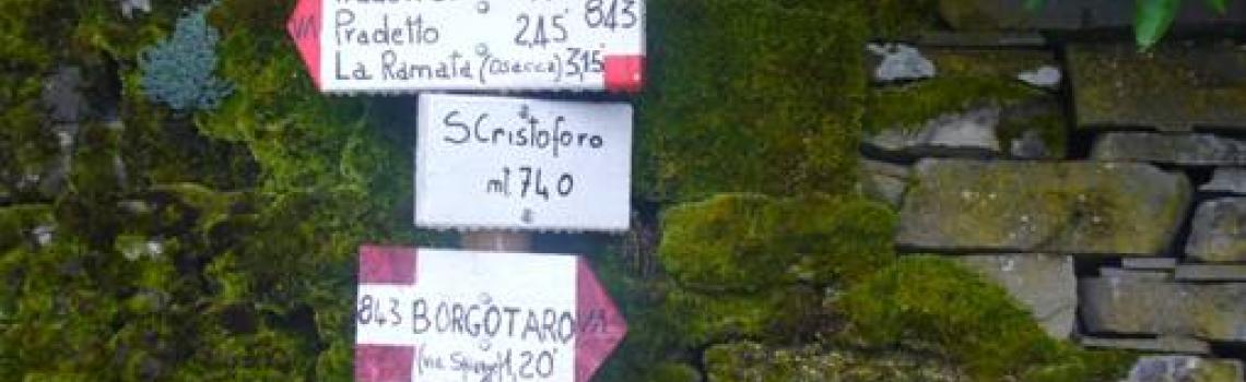
Past the mill, after about 50 metres, you take the path on the left and reach Osacca, which in the 17th century was the southern border between the "State of the Landi Prince" and the Duchy of Parma. Here is found an Oratory, a small chapel with a wooden statue of Saint Rocco (pilgrim to Santiago de Compostela), and the plaque commemorating the first armed fight between Partisans and Nazi-Fascists in the Province of Parma: it was the night of December 24, 1943.
Once past the last houses, you go towards La Ramata where, on the left, the 843VA path starts (which continues until it reaches the Borgallo Pass), and you walk to reach the ridge; here you come to a crossroads (with directions); past this, on the left of the route, is the path that leads to the top of Mount Piano, an important scenic point, at 1150 metres above sea level.
From the ridge to Borgo Val di Taro
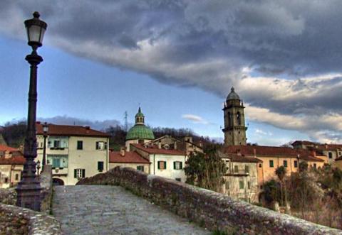
Back on the route, you continue until you reach La Maestà and Pradonico, then descend to Rola, to the Church of S. Cristoforo (which was built in the Middle Ages, as was the church dedicated to St. Peter and located a bit further down valley - off route), Mount Cappella, Le Spiagge, and finally Borgo Val di Taro.
Considered the capital of the valley, this small town is located within what was Curtis Turris, perhaps the largest farming property of the St Columbanus Monastery of Bobbio: in the mid-9th century, in addition to the lands managed directly by the monks, 85 farming families lived here. From these lands the Monastery received a quarter of the production of cereal, half of the wine and a great amount of labour.
At the turn of the 10th and 11th centuries, the Platoni family were feudal lords in the valley; initially powerful leasees of the Bobbio abbots, they took advantage of the decline of the monastery to appropriate the lands that they were overseeing. In the 12th century, the territory came under the rule of the Commune of Piacenza and later of the Landi Princes and of Ottavio Farnese, Duke of Parma, whom the local inhabitants nominated as their Prince. This was followed, in order, by rule by the French Empire, Maria Luigia of Austria and the Bourbons, and finally by the unification of Italy.
The oldest part of the town is characterized by an interesting road layout, consisting of three long parallel streets, part of a pre-ordained urban plan, believed to be due to the establishment of a free town by the Commune of Piacenza. There are 16th- and 18th-century buildings of great historical and architectural interest: Bertucci Palace, a five-story building near the Taro river, Manara Palace, seat of the Manara Library, with a remarkable old collection including manuscripts, incunabula,and books published in the 16th century, Boveri Palace, outstanding for its rich stucco decoration interspersed with the coat of arms of the Farnese, Bourbon and local families.
The parish church, built around 1664 and later reworked, dedicated to Saint Antonino, has a 15th century wooden crucifix, a choir section and notable furnishings. Other churches are San Rocco (with a splendid 17th century Via Crucis by Gaspare Traversi), and San Domenico, started in 1449 in late-Gothic style. The Museo delle Mura, a museum located in the stump of the only surviving tower of the Medieval castle, exhibits memories and artifacts of the life of the town.
The town is the capital of the mushroom and seat of the Consortium of Porcini Mushrooms of Borgotaro (PGI).
5 km from the town there is Porcigatone - whose parish church has an imposing and dramatic Crucifixion by the 16th-century painter Giovanni Lanfranco, at 10 km Compiano, a typical medieval village with a castle that belonged first to the Malaspina and then to the Landi family, at 13 km Bedonia, with a Diocesan Seminary that houses an ancient library, an art gallery, the Complete works of the xylographer Romeo Musa, a rich memorial collection about Cardinal Agostino Casaroli, a Museum of Natural History and the Planetarium.
Not far from Borgo Val di Taro we find the Ghirardi Nature Reserve, covering almost 600 hectares, which protects a corner of the Apennines that has remained unchanged. The distinctive morphology of the territory creates the conditions for a mosaic of habitats: we find the hobby falcon at the edge of the meadows, nightingales, warblers and sparrowhawks in the woods of downy oak, and owls, wild board and deer in the chestnut woods. In the streams, where the Epipactis palustric orchid blooms, we find dragonflies, Italian riffle dace and gobies. The short-toed snake eagle builds its nest among the pine trees, and the open areas, meadows and cultivated fields are the realm of the red-legged partridge, pheasant and quail; there are also hoopoes, rigolos, owls and nightjars, hundreds of flowers in spring and summer, among which the rare Ophrys bertoloni. The Nature Reserve is open to visitors every day of the year, free of charge. It can be reached on foot from Porcigatone, by following the yellow/blue signs of the Parma Horse Trails. The Visitor Centre in Pradelle (on the Borgo Val di Taro - Porcigatone road) is open every Sunday from 10:00 AM to 5:00 PM (6:00 PM in Summer Time); it includes an interesting botanical route.
From Borgo Val di Taro to Pontremoli
From Borgo Val di Taro a unique route leads to the Borgallo Pass (965 m.). You take the road towards the Cemetery - which has a beautiful Memorial to the Fallen in the Resistance - and a little further on, along the paved road, you reach the dell'Aglio mill, the last water mill in the area, and La Galoppina; alternatively, you can take the 843 bis path towards Valleto, where it joins again with the 843 path. You reach San Vincenzo; here, near the church, a white marble bas-relief, dating from 1606, represents the Virgin with Child and, to her side, the pilgrim Saint Rocco, with pilgrim's staff, dog, cape and shell.
You descend towards the Tarodine stream and cross it on the bridge of the provincial road to reach the houses of Valdena, whose name comes from the feudal lords Hena, a branch of the Platoni family.
Still climbing the 843 path, you reach the Borgallo Pass, where until the 19th century could be found the remains of the Hospice of Saint Bartholomew. On this side of the ridge, a few landmarks show the ancient boundaries between the Duchy of Parma and the Grand Duchy of Tuscany. This area borders the state-owned Brattello Forest, with nature paths and equipped areas.
On the ridge you come across path 00, and follow it to a memorial stone that commemorates the sacrifice of the partisans who fought on these mountains during the Resistance; after about 200 metres the path turns left, leaving the 00, and a detour to the right takes you to Fontana Gilente, a perennial spring, just a little off the path.
Once you have descended into the Verde Valley, an area densely covered by woods, you come across groups of houses such as Farfarà and then reach the small waterfall of Pisciarotta; you ford the stream of the same name and, a little further on, you follow the path along Lago Verde, fed by spring waters.
You cross an old chestnut wood and reach Cervara: here and there along the road are small white pillars carrying devotional marble bas-relief, which remind us that we are near the Apuan marble quarries. The village church, dedicated to Saint George, may go back to Longobard origins. There is evidence of a hospice, built in the 14th century, and traces of apotropaic cults can be found in the facions, the faces sculpted in sandstone that still today from the house facades seem to challenge the weather and ward off evil.
Past the village and the cemetery, you cross the Darnia stream and climb towards Barca, a scenic point from which you can admire the Apennines range from Mount Molinatico to Mount Orsaro and the Apuan Alps, and then reach Pra' del Prete. Right opposite rises the tower of the Castle of Grondola which, from the top of a hill, seems to be checking the paths winding through the valley. In the Middle Ages, the castle was the subject of bitter disputes between the people of Piacenza, Parma, Pontremoli and the Malaspina family.
We would like to thank the Abbots Way Association for the texts and the GPS track.